System (NNSS) became operational. This system is an
all-weather, highly accurate navigation aid, enabling
navigators to obtain accurate navigation fixes from the
data collected during a single pass of an orbiting
satellite.
The following paragraphs describe the NNSS, its
satellites, Doppler principles, system accuracy , and two
common shipboard equipments—the AN-WRN-5( V) and
the AN/SRN-19(V)2.
NAVY NAVIGATION SATELLITE SYSTEM
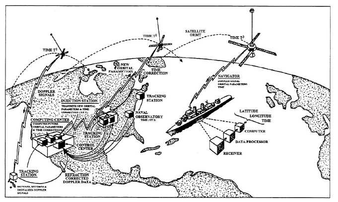
This highly accurate, world-wide, all weather system
enables navigators to obtain fixes approximately every 2
hours, day or night. Looking at figure 1-5, you can see
that it consists of earth-orbiting satellites, tracking
stations, injection stations, the U.S. Naval Observatory,
a computing center, and shipboard navigation
equipment.
System Satellites
Satellites are placed in a circular polar orbit, as
illustrated in figure 1-6, at an altitude of 500 to 700
(nominally 600) nautical miles. Each satellite orbits in
approximately 107 minutes, continually transmitting
phase-modulated data every 2 minutes on two rf
carriers. This data includes time synchronization
signals, a 400-Hz tone, and fixed and variable
parameters that describe the satellite’s orbit.
The fixed parameters describe the nominal orbit of
the satellite. Variable parameters (small corrections to
the fixed parameters) are transmitted at two-minute
intervals and describe the fine structure of the satellite
orbit. The satellite memory stores sufficient variable
parameters to provide the two-minute orbit corrections
for 16 hours following injection of fresh data into the
memory. Since data injections occur about every 12
hours, the satellite memory will not
Figure 1-5.—Navy Navigation Satellite System.
1-6


